By Ruthann Carr, Correspondent
After finding bones, pottery sherds, and fire-cracked quartz dating as far back as 1200 B.C., Circa-Cultural Resource Management (CCRM) recommends further study of the proposed pump station and water line near the confluence of the James and Rivanna Rivers.
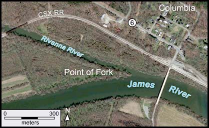
Point of Fork, the land between the two rivers, is long thought to be the “probable location of the historic village of Rassawek, the main settlement of the Monacans,” the report states.
While many artifacts were recovered during the cultural resources survey, CCRM states it is unlikely they’ll ever be able to prove for certain that Point of Fork is the site of Rassawek.
However, archeologists found enough artifacts to recommend phase III study of four of the seven sites excavated.
The 368-page report, dated May 2018, stated the four sites in which the pipeline and bore pits are scheduled to be constructed are also in areas eligible for National Registry designation.
Besides soil tests, the company used drones to take pictures of sightlines of the proposed pump station. It could barely be seen from 40-100 feet in the air.
The study was requested by the U.S. Army Corps of Engineers upon the recommendation of the Virginia Department of Historic Resources (DHR).
As reported earlier in the Fluvanna Review, the James River Water Authority (JRWA) project, a joint venture between Fluvanna and Louisa Counties, consists of a water intake facility on the Point of Fork near Columbia, and a raw water pipeline stretching a little over a mile to Route 6.
From that point, the Louisa County Water Authority will construct its own pipeline at its own expense to funnel water northwest through Fluvanna to Louisa County. Louisa has agreed to “make all reasonable efforts” to provide up to 400,000 gallons of treated water per day to Fluvanna’s Zion Crossroads area by the end of 2018. The cultural excavation study will push back that date.
The JRWA project, which will cost Fluvanna between $4 million and $5 million, has received its permits from the Virginia Marine Resources Commission and the Department of Environmental Quality.
If the U.S. Army Corps of Engineers agrees with CCRM’s report, a plan “will need to be developed that outlines the path forward for mitigating any adverse effects” and fulfilling requirements for dealing with historic properties, according to the report. The Corps will create the plan in consultation with DHR, JRWA, and “several state- and federally-recognized Indian tribes.”
They will also develop treatment plans, which will “outline any agreed-to mitigation, including phase III excavations, the research design, reporting requirements, and curation of artifacts,” according to the report.
DHR was unable to answer questions as to how this process will affect the timeframe for the JRWA project, including when or if the final permit can be expected.
“We want to get it resolved as quickly as we can,” said Randy Jones, public information officer. “But I don’t know what the timeline is.”
Editor Christina Dimeo contributed to this story.


