
By Madeline Otten, correspondent, and Christina Dimeo, editor
People who think 2018 was remarkably rainy aren’t crazy – they’re right.
Last year had the dubious distinction of having the second-highest amount of rain in 118 years of records.
According to data from the McCormick Observatory in Charlottesville, 72.14 inches of rain fell in 2018. Normal rainfall for one year is 47.68 inches. That 51 percent jump put 2018 second only to 2003, which saw 74.55 inches of rain.
The third-rainiest year was 1937, with 72.07 inches. 1969, the year in which Hurricane Camille smashed into Fluvanna, came in 14th with 55.97 inches.
Though the years since 2000 make up 15 percent of the 118 years of records, six of the rainiest years, or 24 percent, occurred since 2000.
Local effects
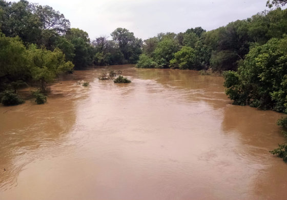
On May 31, the Rivanna River was recorded at its highest point in 2018 at 25.51 feet. The highest the river was ever recorded was back in 1969 at 39.85 feet.
According to the National Weather Service, starting at 17 feet is when the Rivanna River is considered in its flood stage and overflow begins on right banks, or the banks on the right of the river when looking in the direction of the flow, which affects secondary roads. At 18 feet, the river is out of its banks in Palmyra and some streets are closed in town, as are some secondary roads leading into town. Finally, at 24.8 feet, farmland and roads downstream are flooded.
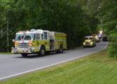
More rain continued to fall and on June 22, nearly 100 streets closed due to flooding throughout Central Virginia after as much as five inches of rain fell. The National Weather Service stated that six inches of moving water is enough to knock over an adult, 12 inches of rushing water can carry away a small car, and two feet of rushing water can carry away most vehicles.
This rainfall sent rivers and creeks over banks, brought down trees, and six roads in Fluvanna County were closed. The next day the Rivanna River was recorded at 19.72 feet.
In July, large trees and debris piled high on the river near the boat ramp by Crofton Bridge, creating a hazard for paddlers out on the water.
It was not until Aug. 20 when a contractor with the Virginia Department of Transportation (VDOT) was able to start removing the large debris pile. Crews accessed the debris from the Crofton boat ramp, which was closed to all traffic. The work was necessary in order to avoid damage to the bridge and to reduce risk of flooding during future storms.
VDOT coordinated the closure with the Department of Game and Inland Fisheries (DGIF) and worked with DGIF and Rivanna Conservation Alliance (RCA) to place signs upstream to warn boaters and paddlers of the debris.
After more rain fell in July and August, the Rivanna rose above 24 feet for the second time in 2018. In September, after the remnants of Hurricane Florence trekked through, the river rose to 24.5 feet and Lake Monticello was recorded at 33 inches above zero, the highest the Lake has ever been recorded. Spillways were opened to drain the lake and reduce the amount above zero.
There was also some damage to roadways. Route 616 (Union Mills Road), between Route 15 and Route 600, was closed due to a washout. Part of the roadway crumbed as a result of heavy overnight rains. The closure affected Fluvanna County residents and their commute to Charlottesville.
“That’s our primary route to Charlottesville, so now instead of leaving and heading west toward Charlottesville, we will have to go east a couple miles then back out to Zion Crossroads to take Interstate 64, which is the only alternative route that we have out here,” said Fluvanna resident William McCorkle at the time.
It unfortunately took longer than expected to fix the road due to more rain in October.On Oct. 11, Fluvanna County received more rain thanks to Hurricane Michael. This also caused Fluvanna to be under tornado and flash flood watches. The Rivanna River rose to 19.97 feet and the heavy amounts of rain caused Fluvanna County schools to close early that day.
Route 616 was closed Sept. 18 and reopened to the public Oct. 29.
“The RCA’s river stewards conducted numerous boat trips down the Rivanna River and its major tributaries this year to investigate the impacts of the high waters and to identify issues that needed attention,” said Lisa Wittenborn, RCA deputy executive director. “They helped scout out the serious logjam that occurred at the Crofton Bridge. They also identified many areas with downed trees (a hazard for boaters) and areas with increased river bank erosion, which contributes to water pollution.”
Recent weather pushed the Rivanna River back above the flooding stage at 19.57 feet on Dec. 21.
“With increasing precipitation, the potential for polluted runoff and trash entering the river also increases,” said Wittenborn. “RCA’s river monitors discovered higher levels of bacteria pollution in the waterways this year than in past years. RCA’s river cleanup volunteers have been working to remove trash and debris from the river banks and from local streams that washed in during the storms.”
The Fluvanna Review thanks Eric Pritchett of NBC29 for his help collecting the statistics.